Saturday, September 14, 2024

Cheeyappara Waterfall, Pazhampillychal, Kerala

Cheeyappara Waterfall, Pazhampillychal, Kerala

Cheeyappara Waterfall is a natural waterfall located near Pazhampillychal Village in Devikulam Taluk in Idukki District in Kerala, India. This waterfall is situated close to Valara Waterfall. It is a seven-step waterfall and is about 1000 feet high. The surroundings of this waterfall is a great place for trekking. Several exotic plant and animal species can be seen in this area. The waterfall is situated adjacent to the highway. The falls offer spectacular views in monsoon and post-monsoon seasons.


Connectivity

The waterfall is located at about 12 Kms from Neriamangalam, 18 Kms from Adimali, 44 Kms from Munnar, 53 Kms from Idukki, 64 Kms from Kochi Airport, 80 Kms from Ernakulam Junction Railway Station and 80 Kms from Kochi. The waterfall is situated between Adimali and Neriamangalam on the Kochi to Munnar highway.

Location 

Charpa Waterfall, Athirappilly, Kerala

Charpa Waterfall, Athirappilly, Kerala

Charpa Waterfall is a natural waterfall located in Athirappilly Village in Chalakudy Taluk in Thrissur District in Kerala, India. This waterfall lies in between the more famous Athirappilly Waterfall and Vazhachal Waterfall. It is a popular stopover for tourists who are visiting the Athirappilly and Vazhachal waterfalls.


The Waterfall

This waterfall is formed by one of the tributary rivers of the Chalakudy River. This waterfall is situated just before the point where this tributary meets the Chalakudy River. The waterfall has a slanting height of about 63 metres and 29 metres width. It is a seasonal waterfall. The best time to visit this waterfall is during monsoon months (June to August). This waterfall is located close to the road and the water flashes onto the road during the monsoon.


Connectivity

The waterfall is located at about 2 Kms from Vazhachal Waterfall, 3 Kms from Athirappilly Bus Stop, 5 Kms from Athirappilly Waterfall, 36 Kms from Chalakudy, 36 Kms from Chalakudy Railway Station, 42 Kms from Kochi Airport, 64 Kms from Thrissur and 67 Kms from Valparai. The waterfall is situated on Chalakudy to Valparai route.

Location 

Ayyapanov Waterfall, Athavanad, Kerala

Ayyapanov Waterfall, Athavanad, Kerala

Ayyapanov Waterfall is a natural waterfall located in Athavanad Village in Tirur Taluk in Malappuram District in Kerala, India. It is a seasonal waterfall and water flow is low during the summer months. The best time to visit this waterfall is during the monsoons.


The waterfall is located at about 6 Kms from Thirunavaya Railway Station, 6 Kms from Puthanathani, 7 Kms from Puthanathani Bus Stand, 9 Kms from Valanchery, 14 Kms from Tirur, 24 Kms from Malappuram and 40 Kms from Kozhikode Airport. The waterfall is situated on the Puthanathani to Thirunavaya route.

Location 

Saturday, July 27, 2024

Rajat Prapat Falls, Pachmarhi, Madhya Pradesh

Rajat Prapat Falls, Pachmarhi, Madhya Pradesh

Rajat Prapat Falls is a waterfall located in Pachmarhi Hill Station inside Satpura National Park in Narmadapuram District in the Indian state of Madhya Pradesh. It is the tallest waterfall of Pachmarhi and is the 30th highest waterfall in India. This falls is also called as Silver Falls / Big Falls. Pachmarhi is famously known as the Queen of Satpura.

The Waterfall

This falls is a horsetail type waterfall with a single drop of 107 metres (351 ft). The waterfall shines as silver when sunlight falls on it. Hence, the falls came to be called as Rajat Prapat (Rajat means silver & Prapat means falls). This fall is situated inside the Satpura National Park and the visitors need to take permission from the forest department. The falls can be viewed from a viewpoint situated in the opposite direction.

No one is allowed to go near the waterfall. Tourist can also have a panoramic view of the lush green Satpura ranges from this point. This falls is nearly half a km towards the east of Apsara Vihar and can be reached by a 15-minute walk over rocks and boulders from Apsara Vihar. Rajat Prapat originates from the same stream Apsara Kund comes from. The best time to visit this waterfall is during post monsoon.

Connectivity

The falls is located at about 3 Kms from Pachmarhi Bus Stand. Pachmarhi is located at about 29 Kms from Matkuli, 52 Kms from Pipariya Railway Station, 54 Kms from Pipariya, 108 Kms from Gadarwara, 119 Kms from Narmadapuram, 120 Kms from Narmadapuram Railway Station, 122 Kms from Itarsi, 136 Kms from Chhindwara, 156 Kms from Narsinghpur, 210 Kms from Bhopal and 222 Kms from Bhopal Airport. Pachmarhi is well connected from Narmadapuram, Chhindwara, Bhopal, Indore, Itarsi, Gadarwara and Narsinghpur. Buses start from Rani Kamalapati ISBT of Bhopal and generally take close to 5–6 hours to reach Pachmarhi.

Location

Purwa Falls, Purwa, Madhya Pradesh

Purwa Falls, Purwa, Madhya Pradesh

Purwa Falls is a waterfall located in Purwa Village near Semariya Town in Rewa District the Indian state of Madhya Pradesh. This waterfall is on the Tons river, descending the cliff of Rewa Plateau. It is one of the top five waterfalls in Rewa district and a must-visit place for the unique topography.


The Waterfall

This waterfall falls from a height of about 70 metres (230 ft). The Tons River while descending through the Rewa Plateau and draining northwards makes this vertical waterfall. It is an example of a nick point caused by rejuvenation. Knick point, also called a nick point or simply nick, represents breaks in slopes in the longitudinal profile of a river caused by rejuvenation. The break in channel gradient allows water to fall vertically giving rise to a waterfall. The best time to visit this waterfall is during monsoon.


Connectivity

The falls is located at about 3 Kms from Godaha, 12 Kms from Semariya Bus Stand, 13 Kms from Semariya, 17 Kms from Sirmaur, 31 Kms from Rewa Railway Station, 32 Kms from Rewa, 55 Kms from Satna, 55 Kms from Satna Airport and 167 Kms from Khajuraho Airport. The falls is situated at about 3 Kms to the north of Godaha on Rewa to Sirmaur route.

Location

Pandav Falls, Panna, Madhya Pradesh

Pandav Falls, Panna, Madhya Pradesh

Pandav Falls is a natural waterfall located near Panna Town in Panna Taluk in Panna District in the Indian state of Madhya Pradesh. It is situated inside the Panna National Park.


Legends

As per legend, Pandavas of the Mahabharata had resided in the Padava Caves situated near the falls during their exile. The caves and the shrines visited by the Pandavas can be near the water pool formed at the end of the fall. The waterfall is named after them.


The Waterfall

The waterfall is about 30 metres (98 ft) high. It is a perennial waterfall fed by a tributary of the Ken River. It forms a heart shaped pool at its bottom. There are few ancient caves at the foot of the waterfall overlooking a large pool of water. The forest around the falls is home to monkeys and bears.


Entry Fees

·      Guide Fee: Rs. 100

·      On foot or bicycle: Rs. 25 per person

·      For two wheelers: Rs. 50 for two persons

·      For three wheelers: Rs. 100 for three persons

·      For four wheelers: Rs. 150 for six persons

·      For mini bus: Rs. 300 for twenty persons

Connectivity

The waterfall is located at about 7 Kms from Madla, 14 Kms from Panna, 14 Kms from Panna Bus Stand, 27 Kms from Khajuraho Junction Railway Station, 30 Kms from Khajuraho Airport and 32 Kms from Khajuraho. The waterfall is situated on the Panna to Khajuraho route.

Location

Panna Tiger Reserve – The Tiger Reserve

Panna Tiger Reserve – The Tiger Reserve

The tiger reserve covers an area of about 1645.08 sq. kms. The core area is about 542.66 sq. kms and the buffer area is about 1002.42 sq. kms. The Khen Gharial sanctuary is about 78.53 sq. kms and Gangau wildlife sanctuary is about 45.20 
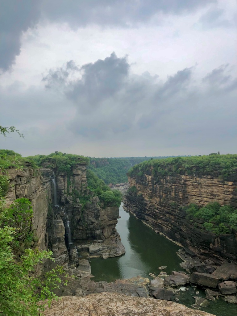
sq. kms. The reserve is located on either side of Ken river which flows from south to north through the Lower Vindhyan Formations within the park. The Ken river, which flows through the reserve from south to north, is home for Gharial and Mugger, and other aquatic fauna and is one of the least polluted rivers and a tributary of Yamuna.


It is one of the sixteen perennial rivers of Madhya Pradesh and is truly the life line of the Reserve. The terrain of the reserve is characterized by extensive plateaus and gorges. The reserve which has a bench topography, can broadly be divided into three distinct tablelands on Panna side namely the upper Talgaon Plateau, the middle Hinnauta plateau and the Ken valley. A series of undulating hills and plateaus rise on the other side of Ken river in Chhatarpur district.


The forests of the tiger reserve along with Ken Gharial Sanctuary and adjoining territorial divisions form a significant part of the catchment area of the river Ken with a total length of 406 km runs for about 72 kms through this catchment. The tiger reserve along with the surrounding territorial forest area of North and South Panna divisions is the only large chunk of wildlife habitat remaining in North Madhya Pradesh in otherwise fragmented forest landscape of the area. Panna National Park represents one of the important Tiger habitats of Central Indian Highlands along with its associated species.


Flora:

The tiger reserve is situated at a point where the continuity of the tropical and subtropical dry broadleaf forests belt, which starts from Cape Comorin in South India, is broken and beyond this the Upper Gangetic Plains moist deciduous forests of the great Indo-Gangetic Plain begins. This area is the northernmost tip of the natural teak forests and the easternmost tip of the natural Kardhai (Anogeissus pendula) forests. The dry and hot climate, in union with shallow Vindhyan soils has given rise to dry teak and dry mixed forest. The dominating vegetation type is miscellaneous dry deciduous forest interspersed with grassland areas.


Other major forest types are riverines, open grasslands, open woodlands with tall grasses and thorny woodlands. The dominant trees found here are Tectona grandis, Diospyros melanoxylon, Madhuca indica, Buchnania latifolia, Anogeissus latifolia, Anogeissus pendula, Lannea coromandelica, Bosswelia serrata etc. The important shrub found here Lantana camera, Grewia sp., Nyctanthus arbortristis, Ixora sp., Zyziphus mauritiana, Zyziphus oenoplea, etc. The dominant grass species are Apluda mutica, Themeda quadrivalvis, Meteropogon contortus, Arishtida sp. etc.


Fauna:

The mammals found in the reserve are tiger, leopard, wild dog, wolf, hyaena, caracal, rusty-spotted cat, Asian palm civet, sloth bear, sambar, chital, chausingha, nilgai, and chinkara. The reserve is home to more than 200 species of birds. Some of the birds found in the reserve are white necked stork, bar headed goose, crested honey buzzard, Indian vulture, blossom headed parakeet, paradise flycatcher, Slaty headed Scimitar babbler, red-headed vulture, and changeable hawk-eagle. The reserve is also home to variety of reptiles including the python.


Najara View Point, Bhainsa, Madhya Pradesh

Najara View Point, Bhainsa, Madhya Pradesh Najara View Point is a view point located near Bhainsa Village in Jabera Taluk in Damoh Distric...