Saturday, February 4, 2023

Apsara Vihar Falls, Pachmarhi, Madhya Pradesh

Apsara Vihar Falls, Pachmarhi, Madhya Pradesh

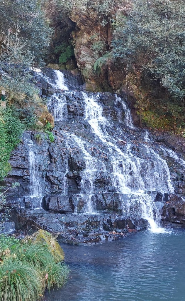
Apsara Vihar Falls is a waterfall located in Pachmarhi Hill Station inside Satpura National Park in Narmadapuram District in the Indian state of Madhya Pradesh. This falls is situated close to Pandava Caves in Pachmarhi. Pachmarhi is famously known as the Queen of Satpura.


Legends

Pachmarhi was the summer capital of Britishers during their colonial rule. It is said that the English women used to bathe in this pool to beat summer during the British rule time in India. As the English ladies wore white clothes while bathing, locals thought them to be fairies and hence named the pool as Apsara Vihar or Fairy Pool.


The Waterfall

This falls is about 30 feet tall. A natural bathing pool is formed at the bottom by the falls. The pool is deeper near the fall and shallow towards the end. The water comes from the Rajat Prapat to Apsara falls. This place ideal for swimming. The path leading to the pool need to be approached only by foot. The best time to visit this waterfall is during post monsoon. This place remains closed in case of heavy rainfall.


Connectivity

The falls is located at about 3 Kms from Pachmarhi Bus Stand. Pachmarhi is located at about 29 Kms from Matkuli, 52 Kms from Pipariya Railway Station, 54 Kms from Pipariya, 108 Kms from Gadarwara, 119 Kms from Narmadapuram, 120 Kms from Narmadapuram Railway Station, 122 Kms from Itarsi, 136 Kms from Chhindwara, 156 Kms from Narsinghpur, 210 Kms from Bhopal and 222 Kms from Bhopal Airport. Pachmarhi is well connected from Narmadapuram, Chhindwara, Bhopal, Indore, Itarsi, Gadarwara and Narsinghpur. Buses start from Rani Kamalapati ISBT of Bhopal and generally take close to 5–6 hours to reach Pachmarhi.

Location

Dabhosa Falls, Jawhar, Maharashtra

Dabhosa Falls, Jawhar, Maharashtra

Dabhosa Falls is a waterfall located in Dabhosa Village in Jawhar Tehsil in Palghar District in Maharashtra, India. It is considered as one of the highest waterfalls situated near Mumbai.


The Falls

It is located over the Lendi River and cascades down from a height of 300 feet. It forms a pool at the bottom. The falls is situated amidst dense forest. It is best to visit this falls during the monsoon. It is an adventurous spot for Kayaking, Valley Crossing, Zip Line, Rappelling and laddering, trekking and fishing.


Connectivity

The falls is located at about 15 Kms from Jawhar Bus Stand, 15 Kms from Jawhar, 62 Kms from Trimbak, 84 Kms from Palghar, 91 Kms from Nashik, 123 Kms from Thane, 143 Kms from Mumbai Airport and 144 Kms from Mumbai. The falls is situated at about 15 Kms from Jawhar on Nashik to Mumbai route.

Location

Sadu Chiru Waterfall, Leimaram, Manipur

Sadu Chiru Waterfall, Leimaram, Manipur

Sadu Chiru Waterfall is a waterfall located in Sadu Chiru Village near Leimaram Village in Bishnupur District in the Indian state of Manipur. This waterfall is also called as Leimaram Waterfall.


The Waterfall

This waterfall is a cascade waterfall of about 300 metres high. It is a perennial waterfall in the middle of the forest. One has to trek a short distance to reach the waterfall. It is said that the waterfall was manually enlarged and brought to the present state by the hard work of Sadu Chiru villagers. There are two more falls hidden beneath this green forest, but they are not open to public, perhaps because of the precarious and steep landscapes. The months from October to March, i.e., the winter season are considered the best time to visit Sadu Chiru Waterfall.

Connectivity

The falls is located at about 5 Kms from Leimaram, 9 Kms from Leimaram Lamkhai Bus Stop, 18 Kms from Bishnupur, 20 Kms from Imphal Airport, 28 Kms from Imphal, 29 Kms from Imphal Bus Stand, 78 Kms from Senapati and 230 Kms from Dimapur Railway Station. The falls is situated at about 9 Kms to the north west of Leimaram Lamkhai Bus Stop on Imphal to Bishnupur route.

Location

Nohkalikai Falls, Cherrapunji – Legends

Nohkalikai Falls, Cherrapunji – Legends

As per legend, a young widow named Ka Likai with her infant daughter lived in a called Rangjyrteh, upstream from Nohkalikai Falls. In order to sustain herself and feed her child, she took on the arduous job of a porter. Her work required her to leave the child unattended for long periods. Realizing the difficulties facing in the parenting, she decided to remarry for the sake of her daughter.

Accordingly, she married a guy. However, as mother to an infant, she was obliged to give her daughter constant attention, at the expense of giving her wicked second husband the love he thought he deserved. A fit of jealousy grew in her second husband which manifested into hatred towards his step daughter. One day, he killed the infant and cooked her flesh. He threw the severed head and bones of the infant in order to hide his heinous crime.

When Ka Likai returned, she found the house empty, but she found his husband had prepared a meal. She wanted to go and look for her daughter, but she was so hungry due to her heavy works. She consumed the food prepared by his husband. Ka Likai used to chew betel leaves and nuts after her meal. She was horrified to discover a severed finger near the place where she usually prepare her betel nuts and betel leaves.

Realizing the heinous act of her husband, she went mad with anger and grief and began to run frenziedly, all the while swinging a hatchet in her hand. She finally ran right off the edge of the plateau, plunging to her death, unable to bear any longer the thought that she had unknowingly cannibalized her murdered daughter. The waterfall, from which she leaped was named Nohkalikai Falls as a grim reminder of the tragedy that had befallen the unfortunate Ka Likai.

Nohkalikai Falls, Cherrapunji, Meghalaya

Nohkalikai Falls, Cherrapunji, Meghalaya

Nohkalikai Falls is a waterfall located near Cherrapunji Town (also known as Sohra) in Sohra District in the Indian state of Meghalaya. It is the tallest plunge waterfall in India and the 4th highest falls in the World. This waterfall is tucked in between evergreen rainforests of Khasi Hill. Cherrapunji is one of the wettest places on Earth.


Legends

For brief details, please refer below link;

https://explore-natural-beauty-of-india.blogspot.com/2023/02/nohkalikai-falls-cherrapunji-legends.html

The Waterfall

Nohkalikai Falls is located on the edge of the Cherrapunji Plateau and is about 340 metres (1,115 feet) high. This waterfall is fed by the rainwater collected on the summit of a comparatively small plateau and decrease in power during the dry season, from December to February. There is a plunge pool below the falls with water of an unusual shade of green during summer and sky blue during winter. The viewpoint along the cliff gives you a panoramic view of the falls. Tourists can trek to the edge of the falls as wells as to the bottom of the falls.

The trek to the edge of the waterfall passes through lush grasslands, streams, boulders. A three-tiered waterfall named Tlai falls can be seen on the way. It takes around two hours to reach the edge of the falls. The trek to the pool at the bottom of the fall is very difficult as it required a lot of climbing down the rocks and boulders. The best time to visit the waterfalls is during the months of June to November. There are entry fees to visit this waterfall.

Connectivity

The falls is located at about 7 Kms from Cherrapunji, 44 Kms from Mawngap, 54 Kms from Shillong, 69 Kms from Mairang, 80 Kms from Shillong Airport and 146 Kms from Guwahati Railway Station. Cherrapunji is well connected to Shillong and Guwahati by road. Taxis are available from Cherrapunji to reach this waterfall.

Location

Elephant Falls, Shillong, Meghalaya

Elephant Falls, Shillong, Meghalaya

Elephant Falls is a waterfall located in outskirts of Shillong City in East Khasi Hills District in the Indian state of Meghalaya. The waterfall is located in Upper Shillong area within the Eastern Air Command of Indian Air Force.


History

The original Khasi name for the falls is Ka Kshaid Lai Pateng Khohsiew, which translates to the three - step waterfall. This name is still used locally. However, the modern name is explained by a signboard near the waterfall. The name originated in the British era when the Englishmen spotted a giant rock that looked like an elephant near the fall. This rock was destroyed in the 1897 due to an earthquake.


The Waterfall

Elephant Falls is a 3-tier waterfall. The first fall of Elephant Falls is an example of a horsetail-punchbowl waterfall. The first fall is very broad and is hidden among trees. The second fall, however, is quite domesticated and in the winters (and drier months) looks inconsequential. The third fall is the tallest and comes to view suddenly and looks most spectacular with crystal clear water falling over sharp rocks of myriad shapes.


The sides of the waterfall are flanked by lush greenery and are rich in ferns. One need to navigate through steep and slippery flight of stairs from the gate to reach each level of the fall. The first and second level facilitated with benches to rest and relax. There is a bridge traversing the stream between the second and third level of the falls. The best time to visit the waterfalls is during the post monsoon. There are entry fees to visit this waterfall.


Connectivity

The falls is located at about 10 Kms from Mawngap, 12 Kms from Shillong, 13 Kms from Shillong Bus Stand, 33 Kms from Mairang, 34 Kms from Shillong Airport, 103 Kms from Guwahati Railway Station, The falls is situated on Shillong to Mawngap route.

Location

Vantawng Falls, Thenzawl, Mizoram

Vantawng Falls, Thenzawl, Mizoram

Vantawng Falls is a waterfall located in Buangpui Village to the south of Thenzawl Town in Serchhip District in the Indian state of Mizoram. It is called as Vantawng Khawhthla in Mizo language. It is the highest uninterrupted waterfall in Mizoram. It is believed to be the 13th highest waterfall in India.


Legends

This waterfall is named after Vantawnga, who was said to be an excellent swimmer. It is said that Vantawnga could hover in the cascading water like a fish, but unfortunately, during one of such performances, a drifting log fell from above and killed him.


The Waterfall

The falls is tucked amidst dense forests and resembles a stream of milk. This falls is located in the Vanva river. The height of the falls is about 750 feet. Though, it is difficult to get close to it because of the sheer forested hillsides surrounding it. A viewing tower has been constructed for viewing this waterfall comfortably. The best time to visit this waterfall is during post monsoon.


Connectivity

This falls is located at about 7 Kms from Thenzawl, 39 Kms from Serchhip, 71 Kms from Lunglei, 98 Kms from Aizawl, 128 Kms from Lengpui Airport and 271 Kms from Silchar Railway Station. The falls is situated on Thenzawl to Lunglei route.

Location

Tuirihiau Falls, Thenzawl, Mizoram

Tuirihiau Falls, Thenzawl, Mizoram

Tuirihiau Falls is a waterfall located in Buangpui Village to the south of Thenzawl Town in Serchhip District in the Indian state of Mizoram. It is called as Tuirihiau Khawhthla by the locals.


The Waterfall

This falls is a cascade waterfall located in the Vanva river. It is situated on the upstream of the Vantawng falls. The uniqueness of this waterfall is that there are caves behind the waterfalls, and the falls can be seen from behind. The best time to visit this waterfall is during post monsoon.


Connectivity

This falls is located at about 7.5 Kms from Thenzawl, 39 Kms from Serchhip, 71 Kms from Lunglei, 98 Kms from Aizawl, 128 Kms from Lengpui Airport and 271 Kms from Silchar Railway Station. The falls is situated on Thenzawl to Lunglei route.

Location

Colomb Beach, Palolem, Goa

Colomb Beach, Palolem, Goa Colomb Beach is a public beach located in Palolem Village in Canacona Taluk in South Goa District of Goa, India. ...