Showing posts with label Forts. Show all posts

Thursday, January 2, 2025

Palpur Fort, Palpur, Madhya Pradesh

Palpur Fort, Palpur, Madhya Pradesh

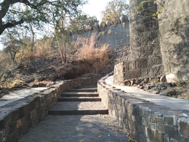
Palpur Fort is an ancient fort located in Palpur Village in Vijaypur Taluk in Sheopur District of Madhya Pradesh in Central India. This fort is situated inside the Kuno National Park. This fort is situated on the left bank of the Kuno River.

History

Palpur, Sabalgarh, Sumawali, and Vijaypur forts were built by the rulers of Sabalgarh, who were Jadon Rajputs from Karauli. The Palpur fortress was probably rebuilt in the beginning of the 18th century by Raja Gopal Singh of Karauli. Later, it was taken from Dhandheles, who were under Karauli Raja. The Jaghirdars of Palpur draw their line from Yaduvanshi (Jadon) Rajputs. They are descendants of Bali Bahadur, son of Raja Dwarka Das of Karauli (1569).  

As per historians, this fort served as a sanctuary to Chandravanshi Raja Bal Bahadur Singh, who assumed the throne in 1666. Later, Thakur Barjor Singh obtained Palpur Jagir from his father Rupnarayan Singh. Thakur Jawan Singh captured Palpur from Dhandheles in 1794 CE. Thakur Balabhadra Singh, Pratap Singh, Jaisingh, Shivratan Singh Madho Singh and Kishor Singh ruled Palpur as Jaghirdars consequently. Thakur Jagmohan Singh was the last ruler of Palpur Thikana who has since shifted to Gwalior.

The Fort

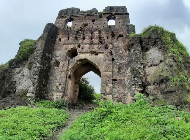
The fort is enclosed by a massive wall with imposing bastions at regular intervals. It was protected by the Kuno River as a natural defence. A temple and Kachahari still exist inside the fort. The fort has two entrance gates. The second gate has two storeys.

Connectivity

The fort is located at about 18 Kms from Agara, 39 Kms from Vijaypur, 39 Kms from Vijaypur Bus Stand, 67 Kms from Sabalgarh, 78 Kms from Padarkheda Railway Station, 110 Kms from Shivpuri, 157 Kms from Sheopur and 167 Kms from Gwalior Airport. The fort is situated about 39 Kms to the south west of Vijaypur on the Sabalgarh to Shivpuri route.

Location

Amet Fort, Amet, Madhya Pradesh

Amet Fort, Amet, Madhya Pradesh

Amet Fort is an ancient fort located in Amet Village in Karahal Taluk in Sheopur District of Madhya Pradesh in Central India. This fort is now almost engulfed in shrubs. This fort is believed to be built by Chandravanshi Raja Bal Bahadur Singh in 17th century CE. This fort is situated inside the Kuno National Park.


Connectivity

The fort is located at about 17 Kms from Karahal, 17 Kms from Karahal Bus Stand, 22 Kms from Sesaipura, 58 Kms from Sheopur, 79 Kms from Shivpuri Railway Station, 83 Kms from Shivpuri and 183 Kms from Gwalior Airport. The fort is situated at about 17 Kms to the north east of Karahal on the Sheopur to Shivpuri route.

Location

Saturday, September 14, 2024

Singorgarh Fort, Singrampur, Madhya Pradesh

Singorgarh Fort, Singrampur, Madhya Pradesh

Singorgarh Fort is an ancient hill fort located in Singrampur village in Jabera Taluk in Damoh District in Madhya Pradesh, India. It is known as one of the most magnificent forts of Gonds. It is situated inside the dense forests of Veerangana Durgavati Tiger Reserve. It is presently under the control of Archeological Survey of India.


History

The fort was built by the Pratihara Rajputs, who ruled in the Damoh region during the 14th century CE. The earliest inscription found in Singorgarh is dated to 1307 CE. The inscription records the name of the fort as Gaja-Singhadurggye, meaning the hill fortress of Gaja Singh. Gajsimha or Gaja Singh Pratihar was a Pratihar Rajput ruler after whom the fort is believed to be named. The Pratihara rule over Singorgarh probably ended with the invasion of the Delhi Sultan Ala-ud-din Khalji's forces, who were going to the Deccan and conquered Bundelkhand on their march.


The fort was conquered by the Gond ruler of Garha-Katanga, Sangram Shah in the 16th century CE. The fort was strengthened by the Gonds of Garha Kingdom. The fort was attacked in the June of 1564 during the invasion of the Garha Kingdom by the Mughal forces. During the invasion, Rani Durgavati, the ruling Queen of Gondwana, resided in Singorgarh and later moved to Chouragarh Fort in Narsinghpur due to the threat she faced during the invasion.

The Fort

This fort is situated on a hill in the dense forests of the Satpura range. The fort is in a ruined state. The fort spread over a vast area and many of its watch towers are still intact. The ruins of Rani Mahal, Hathi Darwaza and a huge bathing tank can be seen in the fort. There are many secret passages in this fort designed to confuse invaders and to provide safe passage for the king and queen.


It is said that there are tunnels deep inside the dungeons known only to Rani Durgavati and a handful of her army. One tunnel discovered by the Archaeological Survey of India (ASI) is said to lead to the hill fort of Madan Mahal. Singorgarh lake is situated close to the Hathi Darwaza. As per local folklore, there is a well inside this reservoir where the treasure of Rani Durgavati along with the Paras Pathar (Philosopher’s Stone) has been hidden.  


Connectivity

The fort is located at about 7 Kms from Singrampur, 19 Kms from Jabera, 44 Kms from Sihora, 46 Kms from Sihora Road Railway Station, 57 Kms from Jabalpur, 59 Kms from Damoh, 62 Kms from Jabalpur Railway Station and 75 Kms from Jabalpur Airport. The fort is situated at about 7 Kms to the west of Singrampur on the Damoh to Jabalpur route.

Location

Thursday, July 25, 2024

Bandhavgarh Fort, Bandhavgarh, Madhya Pradesh

Bandhavgarh Fort, Bandhavgarh, Madhya Pradesh

Bandhavgarh Fort is an ancient fort located in Bandhavgarh Village in Bandhavgarh Taluk in Umaria District of Madhya Pradesh in Central India. The fort is situated on the Bandhavgarh hill at an elevation of 811 meters above sea level in the Vindhyan mountain range. This fort is situated in the dense forests of Bandhavgarh Tiger Reserve.


Legends

As per legend, Lord Rama along with his brother and Lakshman stayed at this place while on his way to Ayodhya after defeating Ravana, the demon king of Lanka. During his stay, Lord Rama asked Nar and Neel to build a fort at this place in order to keep an eye on Lanka as the place is situated on the highest hill in Central India. Then, he handed over the fort to his younger brother, Lakshmana to keep watch on Lanka and the surrounding region. As Lord Rama gave this fort as gift to his brother Lakshmana, the fort came to be called Bandhavgarh (Bandhava means brotherhood and Garh means fort). This incident is mentioned in the Narada Pancharatna and Shiv Samhita Purana Gatha.

History

For brief details, please refer below link;

https://explore-natural-beauty-of-india.blogspot.com/2024/07/bandhavgarh-fort-bandhavgarh-history.html

The Fort Complex

For brief details, please refer below link;

https://explore-natural-beauty-of-india.blogspot.com/2024/07/bandhavgarh-fort-bandhavgarh-fort-complex.html

Connectivity

The fort is located at about 10 Kms from Tala, 35 Kms from Umaria, 36 Kms from Umaria Railway Station, 63 Kms from Beohari, 82 Kms from Shahdol, 183 Kms from Jabalpur Airport and 228 Kms from Khajuraho Airport. The fort is situated at about 10 Kms to the south of Tala on Umaria to Beohari route.

Location

Kuno National Park – The National Park

Kuno National Park – The National Park The national park is situated in an isolated hill, sloping in all directions. The national park ...