Friday, February 28, 2025

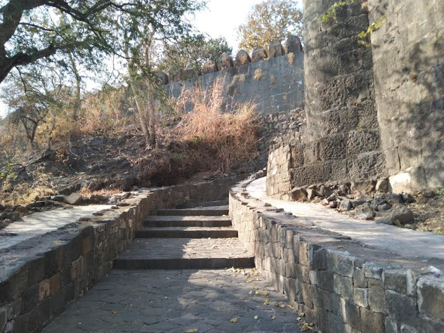
Narnala Fort, Shahanur, Maharashtra

Narnala Fort, Shahanur, Maharashtra

Narnala Fort is a hill fortress situated in Shahnoor Village in Akot Taluk in Akola District in the Indian State of Maharashtra. The fort is also called as Narnala Qila Sarkar / Shahnoor Fort. The fort complex is situated on an isolated hill at the southernmost tip of the Satpura Hills at an elevation of 932 meters above sea level. The fort is situated within the Melghat Tiger Reserve.


History

For brief details, please refer below link;

https://explore-natural-beauty-of-india.blogspot.com/2025/02/narnala-fort-shahanur-history.html

The Fort Complex

For brief details, please refer below link;

https://explore-natural-beauty-of-india.blogspot.com/2025/02/narnala-fort-shahanur-fort-complex.html

Connectivity

The fort complex is located at about 15 Kms from Popatkhed Dam, 26 Kms from Akot, 26 Kms from Akot Bus Stand, 27 Kms from Akot Railway Station, 75 Kms from Akola, 78 Kms from Harisal and 269 Kms from Nagpur Airport. The fort complex is situated at about 15 Kms to the north-west of Popatkhed Dam on Akot to Harisal route.

Location

Sulai Waterfall, Palaspani, Maharashtra

Sulai Waterfall, Palaspani, Maharashtra

Sulai Waterfall is a waterfall located in Palaspani Village near Popatkhed Dam in Akot Taluk in Akola District in the Indian state of Maharashtra. This waterfall is situated inside the Melghat Tiger Reserve. There are entry fees for the people and vehicles to enter this place. The best time to visit this waterfall is during monsoon period.


Connectivity

The waterfall is located at about 25 Kms from Akot, 25 Kms from Akot Bus Stand, 26 Kms from Akot Railway Station, 63 Kms from Harisal, 75 Kms from Akola, 112 Kms from Amaravati, and 267 Kms from Nagpur Airport. The waterfall is situated at about 6 Kms to the west of Khatkali on Harisal to Akot route.

Location

Khirpani Waterfall, Khirpani, Maharashtra

Khirpani Waterfall, Khirpani, Maharashtra

Khirpani Waterfall is a natural waterfall located in Khirpani Village in Anjangaon Surji Taluk in Amravati District in the Indian state of Maharashtra. This waterfall is situated close to Tongalphodi Dam. This waterfall is situated inside the Melghat Tiger Reserve. It forms a pool at the base of the waterfall. The waterfall can be reached after a walk for about 500 metres from the nearest road. It is advised to visit this waterfall during monsoon to witness its full glory.


Connectivity

The waterfall is located at about 14 Kms from Anjangaon, 14 Kms from Anjangaon Bus Stand, 15 Kms from Anjangaon Railway Station, 36 Kms from Akot, 43 Kms from Paratwada, 87 Kms from Amravati and 228 Kms from Nagpur Airport. The waterfall is situated at about 14 Kms to the north west of Anjangaon on Akot to Paratwada route.

Location

Dharkhora Waterfall, Burhanpur, Maharashtra

Dharkhora Waterfall, Burhanpur, Maharashtra

Dharkhora Waterfall is a waterfall located in Burhanpur Village in Bhainsdehi Taluk in Betul District in the Indian state of Madhya Pradesh. It is a cascade waterfall situated inside the Melghat Tiger reserve. It is about 100 feet tall. The waterfall can be reached after a trek of about 5 Kms (approximately 1 hour) from Burhanpur village. The best time to visit this waterfall is during post monsoon.


Connectivity

The waterfall is located at about 8 Kms from Wazar RTO Check Point, 18 Kms from Paratwada Bus Stand, 19 Kms from Paratwada, 19 Kms from Achalpur City Railway Station, 22 Kms from Achalpur Bus Stand, 22 Kms from Achalpur, 35 Kms from Chikhaldara, 40 Kms from Semadoh, 67 Kms from Amravati, and 208 Kms from Nagpur Airport. The waterfall is situated at about 8 Kms to the north east of Wazar RTO Check Point on Paratwada to Semadoh route.

Location

Gondwagholi Dam, Gondwagholi, Maharashtra

Gondwagholi Dam, Gondwagholi, Maharashtra

Gondwagholi Dam is an earthfill dam located in Gondwagholi Village in Achalpur Taluk in Amravati District in the Indian state of Maharashtra. This dam is locally called Gondwagholi Talav / Gondwagholi Lake. The dam was constructed in 1970 by the Government of Maharashtra.


The Dam

It is an earth-fill gravity dam built across Bhuleshwan River. The height of the dam above lowest foundation is 16.07 m (52.7230 ft) while the length is 360 m (1181.1 ft). The maximum gross storage capacity is 1.13 MCM. This dam is a multipurpose dam used for irrigation and drinking water supply. The dam is also a popular tourist attraction and known for its scenic beauty.

Connectivity

The dam is located at about 7 Kms from Pathrot, 21 Kms from Achalpur, 23 Kms from Paratwada Bus Stand, 23 Kms from Achalpur Bus Stand, 24 Kms from Achalpur City Railway Station, 24 Kms from Paratwada, 41 Kms from Chikhaldara, 46 Kms from Akot, 70 Kms from Amravati and 211 Kms from Nagpur Airport. The dam is situated at about 7 Kms to the north of Pathrot on Paratwada to Akot route.

Location

Khatijapur Dam, Khatijapur, Maharashtra

Khatijapur Dam, Khatijapur, Maharashtra

Khatijapur Dam is an earthfill dam located in Khatijapur Village in Achalpur Taluk in Amravati District in the Indian state of Maharashtra. This dam is locally called Khatijapur Talav / Khatijapur Lake. The dam was constructed in 1967 by the Government of Maharashtra.

The Dam

It is an earth-fill gravity dam built across Gandhari River. The height of the dam above lowest foundation is 17.25 m (56.5944 ft) while the length is 311 m (1020.34 ft). The maximum gross storage capacity is 1.94 MCM. This dam is a multipurpose dam used for irrigation and drinking water supply. The dam is also a popular tourist attraction and known for its scenic beauty.

Connectivity

The dam is located at about 4 Kms from Parsapur, 15 Kms from Achalpur, 16 Kms from Paratwada Bus Stand, 17 Kms from Achalpur City Railway Station, 17 Kms from Achalpur Bus Stand, 17 Kms from Paratwada, 38 Kms from Chikhaldara, 48 Kms from Akot, 63 Kms from Amravati and 205 Kms from Nagpur Airport. The dam is situated at about 4 Kms to the north west of Parsapur on Paratwada to Akot route.

Location

Khirkund Dam, Khirkund Kh, Maharashtra

Khirkund Dam, Khirkund Kh, Maharashtra

Khirkund Dam is an earthfill dam located in Khirkund Kh Village in Akot Taluk in Akola District in the Indian state of Maharashtra. This dam is locally called Khirkund Talav / Khirkund Lake. The dam was constructed in 1999 by the Government of Maharashtra.


The Dam

It is an earth-fill gravity dam built across Arr River. The length of dam is 1419 m, while the height of the dam above lowest foundation is 33.3 m. The maximum / gross storage capacity is 5.608 MCM. This dam is used for irrigation. The dam is also a popular tourist attraction and known for its scenic beauty.

Connectivity

The dam is located at about 19 Kms from Anjangaon, 19 Kms from Anjangaon Bus Stand, 20 Kms from Anjangaon Railway Station, 24 Kms from Akot, 48 Kms from Paratwada, 73 Kms from Akola, 92 Kms from Amravati and 233 Kms from Nagpur Airport. The dam is situated at about 19 Kms to the north west of Anjangaon on Akot to Paratwada route.

Location

Jatra Doh Waterfall, Chikhaldara, Maharashtra

Jatra Doh Waterfall, Chikhaldara, Maharashtra Jatra Doh Waterfall  is a natural waterfall situated in Chikhaldara Hill Station in Chikhalda...