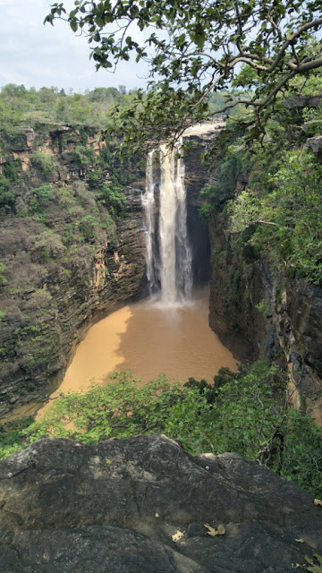
Wednesday, August 2, 2023

Chitrakote Falls, Chitrakote, Chhattisgarh

Chitrakote Falls, Chitrakote, Chhattisgarh

Chitrakote Falls is a waterfall located in Chitrakote Village in Bastar District in the Indian state of Chattisgarh. It is often called as Niagara Falls of India because of its width and its widespread horseshoe shape during the monsoon season. It is one of two waterfalls located near the Kanger Valley National Park, the other being Teerathgarh Falls.


Legends

As per legend, Lord Rama spent his exile in Chitrakote (Dandakaranya). He meditated in the caves here, beside the waterfall.


The Waterfall

It is a natural waterfall situated on the Indravati River. It is surrounded by the majestic grandeur of Vindhya ranges. The height of the falls is about 29 metres (95 ft). It is the widest fall in India, reaching a width of nearly 300 metres (980 ft) during the monsoon season. The beauty of the falls can be seen throughout the year, particularly during sunset. As the fast-flowing water of the river flows over the sharp, near-vertical rock exposure at the widest reach of the river, it generates misty clouds and then hits into a pond formed in a semicircular shape at the bottom of the falls.


During the rainy season, from July to October, rainbows are created with sun rays reflecting on mist from the waterfall. Adventure sports enthusiasts use boats in the stormy part of this pond. Pilgrims bathe in the calmer part of the lake. In the low-flow season, paddle boats are used in pools formed in the upstream part of the falls. In the pool below the falls, swimming and paddle boats are permitted. Local boatmen can paddle their boats under the spray below the falls. It is one of the six waterfalls in India classified as geomorphosites (geo heritage sites with geomorphological interest).


This classification is based on research studies of geological features of heritage value existing in different parts of the country. A small Hindu temple dedicated to Lord Shiva and several naturally formed caves called Parvati caves can be seen on the left bank of the falls. On the banks of the pond below the falls, many small Shiva Lingas (aniconic symbols of the god Shiva) are found in several niches, as are iron trishuls (the trident weapon of Shiva), mostly in a rusted state. 


On the left bank, there is a rock ledge and climbing down this cliff leads to a naturally formed niche which houses stone slabs carved with deities. In addition, there is a small hut made of straw where Shiva images and rusted images of his son, the god Ganesha, are seen. There is a government-run hotel at the top of the falls. A series of steps from the garden of the hotel leads to the falls. Chitrakote log huts with basic and modern cabins have also been built at the location. Some of the cabins provide good views of the falls.


Connectivity

The falls is located at about 33 Kms from Bastar, 42 Kms from Jagdalpur Railway Station, 43 Kms from Jagdalpur Airport and 49 Kms from Barsur. The falls is situated on Jagdalpur to Barsur route.

Location

Teerathgarh Falls, Chattisgarh

Teerathgarh Falls, Chattisgarh

Teerathgarh Falls is a waterfall located at Teerathgarh Village in Kanger Valley National Park in Bastar District in the Indian state of Chattisgarh. This waterfall is a perennial waterfall and can be visited in all seasons. This waterfall is considered one among the highest waterfalls in India.


Legends

As per local folklore, two brothers namely Tirathraj and Chingraj got mesmerized by the beauty of this region and established their fiefdom here. Chingraj established a village named Chingithrai. He constructed his fort and a temple at Chingithrai and ruled over surrounding region. Similarly, Tirathraj established his fort on the lower region of Tirathgarh falls and the established the Tirathgarh village on the upper region. The ruins of the village, temples and his fort can be still seen around Tirathgarh.


The Waterfall

This waterfall is a block type waterfall on the Kanger River. The tributaries of Kanger river Munga and Bahar together produce this beautiful waterfall. The water falls from a height of about 91 metres (299 ft). This waterfall form two to three waterfalls. It is 200 m wide and 110 ft height on the uppermost plains. The rock-cuts are so unique that it gives a unique view to the falls. Again, falling from the height of 125 ft, it forms a second waterfall. Almost after flowing 100 ft, again the distributaries form numerous waterfalls flowing stepwise in 5 to 10m or 1 to 2ft. Due to these numerous waterfalls, Tirathgarh falls is referred to as a cluster of waterfalls.


Here, two major waterfalls falling in two stages contribute to the total height of more than 300 ft. The waterfall is water-flooded during rainy season and flows in its full width along with its channels and gets reflected as a huge cluster of waterfalls whereas after October, it can be viewed in its pure white form. There is a small temple on a large rock opposite the falls. The ruins of ancient Hindu temples can be seen all around the waterfall. A 3 days fair is conducted during Maha Shivaratri here. The best time to see this waterfall is from October to February, along with the rainy season.


Connectivity

The waterfall is located at about 6 Kms from Kanger National Park Kotamsar Booking Counter, 33 Kms from Jagdalpur, 35 Kms from Jagdalpur Railway Station, 37 Kms from Jagdalpur Airport and 81 Kms from Sukma. The waterfall is situated at about 6 Kms to the west of Kanger National Park Kotamsar Booking Counter on Jagdalpur to Sukma route.

Location

Amrit Dhara Falls, Amritdhar, Chattisgarh

Amrit Dhara Falls, Amritdhar, Chattisgarh

Amrit Dhara Falls is a waterfall located in Amritdhar Village in Manendragarh-Chirmiri-Bharatpur District in the Indian state of Chhattisgarh. It originates from the Hasdeo River, which is a tributary of the Mahanadi River. It falls from a height of 90.0 ft (27.4 metres). The waterfall is about 10.0–15.0 ft (3.0–4.6 metres) wide. The water from the falls cascades down from a great height, creating a beautiful misty ambiance. There is a beautiful Shiva temple situated close to this waterfall, A festival called Amritdhara Mahotsav is organized in honor of Lord Shiva of this temple by the district administration every year on Maha Shivaratri.


Connectivity

The falls is located at about 11 Kms from Nagpur, 11 Kms from Nagpur Road Railway Station, 24 Kms from Chirmiri, 29 Kms from Manendragarh, 39 Kms from Baikunthpur, 68 Kms from Bharatpur, 214 Kms from Bilaspur Airport and 330 Kms from Raipur Airport. The waterfall is situated at about 11 Kms to the north of Nagpur on the Manendragarh-Baikunthpur road NH 43.

Location

Telhar Waterfall, Bihar

Telhar Waterfall, Bihar

Telhar Waterfall is a waterfall located near Karar Village in Kaimur District in the Indian state of Bihar. This waterfall is situated on the Rohtas plateau and located close to the origins of Durgavati River. The waterfall is about 80 meters high and falls into the Telhar Kund, situated at the bottom of the waterfall. It is surrounded by amazing views on all sides and is perfect picnic spot. This waterfall is situated close to Durgavati Dam.


Connectivity

The falls is located at about 750 metres from Karar Bus Stop, 3.5 Kms from Karar, 25 Kms from Adhaura, 32 Kms from Bhabua, 46 Kms from Bhabua Road Railway Station, 46 Kms from Mohania, 115 Kms from Varanasi Airport and 122 Kms from Varanasi. The falls is situated on Bhabua to Adhaura route.

Location

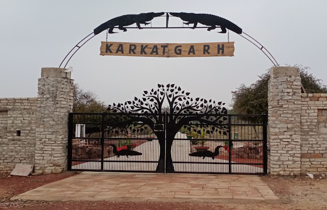
Karkatgarh Waterfall, Bihar

Karkatgarh Waterfall, Bihar

Karkatgarh Waterfall is a waterfall located in Karkatgarh Village in Kaimur District in the Indian state of Bihar. This waterfall is situated on Karmanasa River in Kaimur range. It is a natural habitat of the crocodile. It was a crocodile hunting place for Mughal rulers and British officials. It is said that the British officials constructed a dak bungalow with a view on the 300 feet wide and 100 feet high waterfall. British officials Henry Ramsay mentioned it as the finest fall surrounded by beautiful sceneries. The fall is now part of the Kaimur Wildlife Sanctuary established in 1979 and the hunting of crocodiles and other animals is now prohibited. It is currently a crocodile conservation reserve.


Connectivity

The falls is located at about 27 Kms from Chainpur, 40 Kms from Bhabua, 55 Kms from Bhabua Road Railway Station, 55 Kms from Mohania, 68 Kms from Chandauli, 99 Kms from Varanasi and 136 Kms from Varanasi Airport. The falls is situated at about 27 Kms to the south west of Chainpur on Bhabua to Varanasi route.

Location

Kakolat Falls, Bihar

Kakolat Falls, Bihar

Kakolat Falls is a waterfall located in Kakolat Village near Thali Bazar in Nawada District in the Indian state of Bihar. It is situated on the Kakolat hill, located on the borders of Bihar and Jharkhand. It is a beautiful waterfall and is one of the most visited places in Bihar. This falls was rediscovered by Mr. Francis Buchanan in 1811.


Legends

As per legend, a king was cursed to become a python by a sage Ashtabakra during Treta Yuga. The king in the form of python lived near the Kakolat Falls. He got rid of the curse by the visit of Pandavas to this place during their exile. It is said that any person who bathed in this waterfall would never be reborn as a snake. Hence, several devotees take bath in the waterfall during Vaisakhi or Chaitra Sankranti. It is also believed that Lord Rama with his wife Sita and his brother Lakshmana lived here during their exile.


The Waterfall

The waterfall is situated on the Kakolat hill and surrounded by dense forest. The waterfall cascades down from a height of about 160 feet and forms a deep natural pond at the base of the waterfall. Bathing is allowed in the pond. The bathing area is divided into two sections for men and women to bath comfortably. It is large enough to accommodate around 100 men and women at a time. The herbs growing at the waterfall area are said to contain medicinal qualities. The water is said to be cool even in summer and is rich with minerals which the locals claim to cure some ailments.


Connectivity

The falls is located at about 6 Kms from Thali Bazar, 15 Kms from Akbarpur, 24 Kms from Gobindpur, 31 Kms from Nawada, 31 Kms from Nawada Railway Station, 55 Kms from Rajgir, 85 Kms from Gaya, 94 Kms from Gaya Airport, 141 Kms from Patna and 147 Kms from Patna Airport. The falls is situated at about 6 Kms to the south of Thali Bazar on Akbarpur to Gobindpur route.

Location

Dhua Kund Waterfall, Mahua Dihra, Bihar

Dhua Kund Waterfall, Mahua Dihra, Bihar

Dhua Kund Waterfall is a waterfall located in Mahua Dihra Village near Sasaram City in Rohtas District in the Indian state of Bihar. This waterfall along with Manjhar Kund waterfall is situated on Kaimur Hill. This waterfall is also called as Dhuan Kund.


The Waterfall

The waterfall falls down from a height of about 300 feet. The waterfall is called as Dhua Kund (Dhua means Smoke) because a dense fog covers the area almost every time of the year. The fog looks like smoke from far and hence the name. The Dhua Kund and Manjhar Kund are the source of the Kao River in Bihar which later changes the name to Thori River and enters Bhojpur District and then finally fall in Buxar District. It is said that the water of this waterfall is rich in minerals and considered helpful in digesting food. The waterfall remains crowded throughout the year for its natural beauty. The Dhua Kund and the Manjhar Kund waterfalls have the capacity to generate 50-120 MW of hydroelectricity.


Festivals

A festival is organized every year during Raksha Bandhan in the vicinity of Dhua Kund and Manjhar Kund waterfalls.

Connectivity

The waterfall is located at about 7 Kms from Sasaram Tara Chandi Temple, 14 Kms from Sasaram Junction Railway Station, 15 Kms from Sasaram, 15 Kms from Sasaram Bus Stand, 50 Kms from Aurangabad, 138 Kms from Varanasi and 167 Kms from Varanasi Airport. The waterfall is situated at about 7 Kms to the south of Sasaram Tara Chandi Temple on Sasaram to Aurangabad route.

Location

Najara View Point, Bhainsa, Madhya Pradesh

Najara View Point, Bhainsa, Madhya Pradesh Najara View Point is a view point located near Bhainsa Village in Jabera Taluk in Damoh Distric...