Saturday, February 4, 2023

Nohkalikai Falls, Cherrapunji, Meghalaya

Nohkalikai Falls, Cherrapunji, Meghalaya

Nohkalikai Falls is a waterfall located near Cherrapunji Town (also known as Sohra) in Sohra District in the Indian state of Meghalaya. It is the tallest plunge waterfall in India and the 4th highest falls in the World. This waterfall is tucked in between evergreen rainforests of Khasi Hill. Cherrapunji is one of the wettest places on Earth.


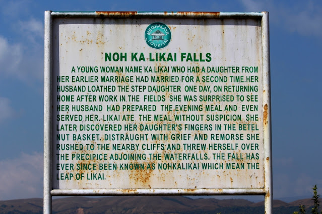
Legends

For brief details, please refer below link;

https://explore-natural-beauty-of-india.blogspot.com/2023/02/nohkalikai-falls-cherrapunji-legends.html

The Waterfall

Nohkalikai Falls is located on the edge of the Cherrapunji Plateau and is about 340 metres (1,115 feet) high. This waterfall is fed by the rainwater collected on the summit of a comparatively small plateau and decrease in power during the dry season, from December to February. There is a plunge pool below the falls with water of an unusual shade of green during summer and sky blue during winter. The viewpoint along the cliff gives you a panoramic view of the falls. Tourists can trek to the edge of the falls as wells as to the bottom of the falls.

The trek to the edge of the waterfall passes through lush grasslands, streams, boulders. A three-tiered waterfall named Tlai falls can be seen on the way. It takes around two hours to reach the edge of the falls. The trek to the pool at the bottom of the fall is very difficult as it required a lot of climbing down the rocks and boulders. The best time to visit the waterfalls is during the months of June to November. There are entry fees to visit this waterfall.

Connectivity

The falls is located at about 7 Kms from Cherrapunji, 44 Kms from Mawngap, 54 Kms from Shillong, 69 Kms from Mairang, 80 Kms from Shillong Airport and 146 Kms from Guwahati Railway Station. Cherrapunji is well connected to Shillong and Guwahati by road. Taxis are available from Cherrapunji to reach this waterfall.

Location

Elephant Falls, Shillong, Meghalaya

Elephant Falls, Shillong, Meghalaya

Elephant Falls is a waterfall located in outskirts of Shillong City in East Khasi Hills District in the Indian state of Meghalaya. The waterfall is located in Upper Shillong area within the Eastern Air Command of Indian Air Force.


History

The original Khasi name for the falls is Ka Kshaid Lai Pateng Khohsiew, which translates to the three - step waterfall. This name is still used locally. However, the modern name is explained by a signboard near the waterfall. The name originated in the British era when the Englishmen spotted a giant rock that looked like an elephant near the fall. This rock was destroyed in the 1897 due to an earthquake.


The Waterfall

Elephant Falls is a 3-tier waterfall. The first fall of Elephant Falls is an example of a horsetail-punchbowl waterfall. The first fall is very broad and is hidden among trees. The second fall, however, is quite domesticated and in the winters (and drier months) looks inconsequential. The third fall is the tallest and comes to view suddenly and looks most spectacular with crystal clear water falling over sharp rocks of myriad shapes.


The sides of the waterfall are flanked by lush greenery and are rich in ferns. One need to navigate through steep and slippery flight of stairs from the gate to reach each level of the fall. The first and second level facilitated with benches to rest and relax. There is a bridge traversing the stream between the second and third level of the falls. The best time to visit the waterfalls is during the post monsoon. There are entry fees to visit this waterfall.


Connectivity

The falls is located at about 10 Kms from Mawngap, 12 Kms from Shillong, 13 Kms from Shillong Bus Stand, 33 Kms from Mairang, 34 Kms from Shillong Airport, 103 Kms from Guwahati Railway Station, The falls is situated on Shillong to Mawngap route.

Location

Vantawng Falls, Thenzawl, Mizoram

Vantawng Falls, Thenzawl, Mizoram

Vantawng Falls is a waterfall located in Buangpui Village to the south of Thenzawl Town in Serchhip District in the Indian state of Mizoram. It is called as Vantawng Khawhthla in Mizo language. It is the highest uninterrupted waterfall in Mizoram. It is believed to be the 13th highest waterfall in India.


Legends

This waterfall is named after Vantawnga, who was said to be an excellent swimmer. It is said that Vantawnga could hover in the cascading water like a fish, but unfortunately, during one of such performances, a drifting log fell from above and killed him.


The Waterfall

The falls is tucked amidst dense forests and resembles a stream of milk. This falls is located in the Vanva river. The height of the falls is about 750 feet. Though, it is difficult to get close to it because of the sheer forested hillsides surrounding it. A viewing tower has been constructed for viewing this waterfall comfortably. The best time to visit this waterfall is during post monsoon.


Connectivity

This falls is located at about 7 Kms from Thenzawl, 39 Kms from Serchhip, 71 Kms from Lunglei, 98 Kms from Aizawl, 128 Kms from Lengpui Airport and 271 Kms from Silchar Railway Station. The falls is situated on Thenzawl to Lunglei route.

Location

Tuirihiau Falls, Thenzawl, Mizoram

Tuirihiau Falls, Thenzawl, Mizoram

Tuirihiau Falls is a waterfall located in Buangpui Village to the south of Thenzawl Town in Serchhip District in the Indian state of Mizoram. It is called as Tuirihiau Khawhthla by the locals.


The Waterfall

This falls is a cascade waterfall located in the Vanva river. It is situated on the upstream of the Vantawng falls. The uniqueness of this waterfall is that there are caves behind the waterfalls, and the falls can be seen from behind. The best time to visit this waterfall is during post monsoon.


Connectivity

This falls is located at about 7.5 Kms from Thenzawl, 39 Kms from Serchhip, 71 Kms from Lunglei, 98 Kms from Aizawl, 128 Kms from Lengpui Airport and 271 Kms from Silchar Railway Station. The falls is situated on Thenzawl to Lunglei route.

Location

Friday, February 3, 2023

Khandadhar Falls, Bonaigarh, Odisha

Khandadhar Falls, Bonaigarh, Odisha

Khandadhar Falls is a waterfall located in Nandapani Village near Bonaigarh Town in Sundargarh District in the Indian state of Odisha. The waterfall looks like a sword from a distance. Hence, it is named as Khanda (sword) Dhara (waterfall). It is the 12th highest waterfall in India and 2nd highest waterfall in Odisha.


Legends

As per legend, the Sundargarh branch of the Pauri Bhuiya tribal community was once possessed by a goddess named Kankala Devi, who consumed trees, soil, and everything else. In despair, the Pauri Bhuiya placed her on a rock, which she ate through as well. Thus, creating a deep hole from which poured out the Khandadhara (split-rock waterfall). So, they had water. Then a couple from the community went to visit relatives at the eastern end of the Khandadhar mountain range. Their prospective hosts were away but a pile of grains had been left outdoors and amazingly, not even the birds were eating it. Inside the heap, the couple discovered a small goddess, Kanta Kumari, protector of the region’s prosperity. They stole her and brought her back to Sundargarh, and so her bounty became theirs.


The Waterfall

This falls is a horsetail type waterfall, created by a perennial stream called Korapani Nala. It plunges from a height of 244 metres (801 ft) in a single drop. It is situated amidst dense forest. The falls can be reached after trekking of about 2 Kms. The best time to visit this waterfall is during post monsoon.


Connectivity

The falls is located at about 20 Kms from Bonaigarh, 20 Kms from Bonaigarh Bus Stand, 81 Kms from Rourkela Junction Railway Station, 85 Kms from Rourkela Airport, 86 Kms from Rourkela, 90 Kms from Kendujhar, 132 Kms from Talcher and 259 Kms from Bhubaneswar Airport. The falls is situated at about 20 Kms to the south east of Bonaigarh on Rourkela to Kendujhar route via Bonaigarh.

Location

Kuno National Park – The National Park

Kuno National Park – The National Park The national park is situated in an isolated hill, sloping in all directions. The national park ...