Thursday, August 3, 2023

Kas Plateau Reserved Forest, Satara, Maharashtra

Kas Plateau Reserved Forest, Satara, Maharashtra

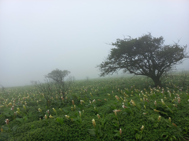
Kas Plateau Reserved Forest, also known as the Kaas Pathar, is a plateau made from volcanic rocks situated in Kaas Village near Satara City in Satara District of Maharashtra, India. It is famously called as Kaas plateau of flowers. It falls under the Sahyadri Sub Cluster of the Western Ghats, and it became a part of a UNESCO World Natural Heritage Site in 2012. It is a biodiversity hotspot known for various types of seasonal wild flowers bloom and numerous species of endemic butterflies annually in the months of August and September.


The Kaas Plateau

The plateau is situated at an altitude of 1200 metres and is approximately 10 square kilometers in area. The flora of kaas are typically restricted to that particular locality only. This is because the plateau is largely formed of basalt which is directly exposed to atmosphere. The basalt is almost covered entirely by a thin cover of soil formed due to erosion and has accumulated a layer of not more than 25 mm or so. Kaas has more than 850 different species of flowering plants. 624 species have entered in the Red Data Book. Out of these 624 species, 39 are found only in Kaas Region. The flora of kaas include orchids, shrubs such as the Karvy, and carnivorous plants such as Drosera Indica. The orchids bloom here for a period of 3 – 4 weeks during monsoon season.


Some of the most common flowering plants are Adenoon indicum, Aerids maculosum, Aponogeton satarensis, Arisaema murrayi, Begonia crenata, Ceropegia jainii, Ceropegia vincifolia, Ceropegia media, Chlorophytum glaucoides, Cyanotis tuberosa, Dendrobium barbatulum, Dioscorea bulbifera, Dipcadi montanum, Drosera burmanni, Drosera indica, Elaeocarpus glandulosus, Exacum tetragonum, Flemingia nilgheriensis, Habenaria grandifloriformis, Habenaria heyneana, Habenaria longicorniculata, Habenaria panchganiensis, Hitchenia caulina, Impatiens oppositifolia, Ipomoea barlerioides, Linum mysurense, Memecylon umbellatum, Murdannia lanuginosa, Murdannia simplex, Nymphoides indicum, Oberonia recurva, Paracaryopsis coelestina, Paracaryopsis malbarica, Pinda concanensis, Pogostemon deccanensis, Rotala fimbriata, Rotala ritchiei, Senecio bombyensis, Senecio grahami, Smithia agharkarii, Smithia hirsute, Trichosanthes tricuspidata, Utricularia purpurascens, Vigna vexillata, Wild Brinjal flower etc.


The plateau also has several invertebrates throughout the year. Tiger beetles are observed mating in large numbers on Kas during September–October. Praying mantises, ants are common. Tadpole shrimps were reported some years back. Fairy shrimps are present in the small pond. The plateau has several signs of presence of barking deers, Gaur, hares, civets and rodents. Ruddy mongoose, Rusty spotted cat have been observed in surrounding scrub area. Presence of Leopard has been reported from the surrounding forest area. Endemic Malabar Lark is commonly observed nesting on the rocky plateau. This is also a haven for bird watchers, as many species of birds can be spotted here. The major portion of the plateau is reserve Forest.


Kaas lake is situated on the south of the Kaas Plateau and is surrounded by dense forest. Kaas lake is a perennial source of water supply for western part of Satara city by gravity. Kaas Plateau overlooks the dense evergreen forests of the Koyna Wildlife Sanctuary and serves as the catchment area of the Koyna Dam. To control possible damage by tourists, the number of visitors to the plateau has been restricted to 3,000 per day. The best time to visit Kas Pathar is from August to October. Many people visit Kaas during the rains; however, the plants bloom only in late August to September. Bhambavli Flower Plateau, largest flower plateau of the world is situated 3 kms away from Kaas Plateau. Bhambavli Vajrai Waterfall is also near Kaas which is one of India's highest waterfalls.


Fees

·      Entry Fee: Rs. 100 /- (No entry fees Children below age 5 years)

·      Bicycle Charges: Rs. 50/- per 1 hour (Deposit Necessary)

·      Guide Charges for group of 10: Rs. 100/-.

Connectivity

Kaas Pathar is located at about 4 Kms from Kaas, 24 Kms from Satara Bus Stand, 25 Kms from Satara, 30 Kms from Satara Railway Station, 38 Kms from Mahabaleshwar, 50 Kms from Panchgani, 50 Kms from Tapola and 145 Kms from Pune Airport. There are two ways to reach Kaas. One is the direct way from Satara and another from Tapola via the link road connecting Mahabaleshwar and Panchgani to Kas Pathar.

Location

Vajrai Falls, Bhambavali, Maharashtra

Vajrai Falls, Bhambavali, Maharashtra

Vajrai Falls is a waterfall located in Bhambavali Village near Khas Pathar in Satara District in the Indian state of Maharashtra. This waterfall is the tallest waterfall in India and second highest plunge waterfall in India after the Nohkalikai Falls in Meghalaya.


Legends

As per legend, Marathi Saint Samarth Ramdas Swami has climbed this mountain in three footsteps because of his climb, the waterfall was converted into three-tiered waterfall.

The Falls

The waterfall is located on the river Urmodi and falls straight down from a straight cliff having three steps (tiers). The height of the waterfall combining all three tiers is 560 m (1840 ft). This is a perennial waterfall but is very spectacular during monsoons. The greenery of the surrounding region is breathtaking. As the waterfall is located inside the dense forest, tourists can see wild animals, butterflies, reptiles, frogs, and various species of trees. June to October is the best time to visit this waterfall. This area is inhabited by a large number of leeches. Swimming at the waterfall is prohibited because of deep ponds.


Connectivity

The falls is located at about 2 Kms from Alawadi Bus Stop, 3 Kms from Kaas Pathar, 4 Kms from Bhambavali, 29 Kms from Satara, 34 Kms from Satara Railway Station, 42 Kms from Mahabaleshwar, 54 Kms from Panchgani, 137 Kms from Pune and 148 Kms from Pune Airport. Buses are available from Satara to Kas Pathar. This waterfall is situated on Satara to Mahabaleshwar route via Kas Pathar.

There is no direct route to this waterfall as it is located in the Sahyadri mountain range. Trekking is the only way to reach this waterfall. The trek starts from Bhambavali village. Bhambavali village can be reached after walking 15-20 minutes from Kas village. The base of the falls can be reached from Alawadi Bus Stop by trekking for about 1 Km. Buses are available from Satara to Alawadi Bus Stop.

Location

Dhareshwar Waterfall, Banoti, Maharashtra

Dhareshwar Waterfall, Banoti, Maharashtra

Dhareshwar Waterfall is located in a remote location off Banoti Village in the Soegaon Taluk of the Aurangabad District in Maharashtra, India. This waterfall is least known in spite of being quite picturesque and enchanting. The falls can be reached after a long trek from the village of Banoti.


The Falls

It is a plunge waterfall falling from a height of about 200 feet. The optical width of the falls is about 20 feet. It is a seasonal waterfall that runs during monsoon season. There is a cave enshrining a Shiva Lingam named Dhareshwar can be seen next to the waterfall. There is an ancient remains of Buddhist monastery dated to 5th century CE can be seen near this waterfall. The monastery is not accessible except with the help of a climbing rope. The existence of this ancient monastery adjacent to the waterfall is largely unknown to the modern world.


Connectivity

Banoti is located at about 35 Kms from Soegaon, 44 Kms from Chalisgaon Junction Railway Station, 48 Kms from Fardapur, 71 Kms from Jalgaon, 92 Kms from Aurangabad and 93 Kms from Aurangabad Airport. The starting point of the trek to the waterfalls is located at about 5 Kms from Banoti. The waterfalls can be reached after trekking for 10 Kms.

Location

Devkund Waterfall, Bhira, Maharashtra

Devkund Waterfall, Bhira, Maharashtra

Devkund Waterfall is a waterfall located in Bhira Village in Mangaon Tehsil in Raigad District in Maharashtra, India. It is the confluence of three waterfalls and is said to be the origin of Kundalika River.


The Falls

It is a plunge waterfall pouring massive amounts of water on the rocky surface underneath. The pool below the falls is a great place for swimming. The greenery surrounding the falls are breathtaking. During the monsoon the water volume increases very quickly due to the design of the hills, so it is unsafe to see the waterfall. It has become extremely crowded and dangerous place. Several lives have been lost while amateurs try to visit this place on their own. The ideal time to go to this waterfall is post monsoon.


Connectivity

The starting point of the falls is located at about 1 Km from Bhira, 2 Kms from Patnus, 7 Kms from Rawalje, 30 Kms from Kolad Railway Station, 32 Kms from Mangaon, 32 Kms from Mangaon Railway Station, 55 Kms from Raigad, 81 Kms from Lonavala, 100 Kms from Pune, 111 Kms from Pune Airport and 125 Kms from Mumbai. It is about a three-hour trek from base village along the dam backwater and through forest to reach this waterfall. A major part of the trek goes through some semi-dried forests with the river running parallel and sometimes crisscrossing through the route. A guide is required to be taken during the trek as there is dense forest around.

Location

Wednesday, August 2, 2023

Indravati National Park, Kutru, Chhattisgarh

Indravati National Park, Kutru, Chhattisgarh

Indravati National Park is a national park located near Kutru Village in Bijapur district of Chhattisgarh state in India. The park derives its name from the Indravati River, which flows from east to west and forms the northern boundary of the reserve with the Indian state of Maharashtra. Indravati National Park is among the most famous wildlife parks of Chhattisgarh. It is one of three Project Tiger sites in Chhattisgarh, along with Udanti-sitanadi, and is home to one of the last remaining populations of the endangered wild water buffalo.


History

This reserve attained the status of a national park in 1981 and a tiger reserve in 1983, becoming one of the most famous tiger reserves in India. The park is reported to be largely under Naxal control.

The Park

The national park covers an area of approximately 2799.08 km2. The topography of the park mainly comprises undulating hilly terrain with altitude ranging between 177 and 599 metres above the sea level. The recommended season to visit the park is from 15 December to 15 June.

Flora:

The vegetation of the Indravati National Park is mainly of the tropical moist and dry deciduous type with predominance of bamboo, sal and teak. There are also patches of grassland providing food to large herbivores such as wild water buffalos, chital, barking deer, nilgai, and gaurs. The most common tree in the park are teak, lendia, salai, mahua, tendu, semal, haldu, ber and jamun.


Fauna:

The park has one of the last populations of the endangered wild Asian buffalo. The national park is also home to a variety of other ungulate species. Some of them are Asian Elephant, gaur (Indian bison), nilgai, blackbuck, chausingha (four-horned antelope), sambar, chital, Indian muntjac, Indian spotted chevrotain and wild boar. Large predators are represented by tigers, leopards, sloth bears, and dholes (wild dogs). Smaller mammals include flying squirrel, porcupine, pangolins, rhesus monkeys and langurs among many others. The commonly found reptiles in the park are freshwater crocodile, monitor lizard, Indian chameleon, common krait, Indian rock python, cobra and Russell's viper. The park also gives shelter to the large variety of birds of which the hill myna is the most important species.


Connectivity

Kutru is the main entry point of the park. Kutru is located at about 34 Kms from Bhairamgarh, 41 Kms from Bijapur, 93 Kms from Bhopalpatnam, 97 Kms from Dantewada Railway Station, 99 Kms from Geedam, 117 Kms from Barsur, 172 Kms from Jagdalpur, 175 Kms from Jagdalpur Airport and 181 Kms from Bastar. Kutru is situated at about 34 Kms to the north west of Bhairamgarh on Jagdalpur to Bhopalpatnam route.

Location

Kuno National Park – The National Park

Kuno National Park – The National Park The national park is situated in an isolated hill, sloping in all directions. The national park ...